
What is Thorong La? (the short answer)
Thorong La, also written Thorung La, is a 5,416 m (17,769 ft) mountain pass in central Nepal, on the Annapurna Circuit, linking Manang district in the Marsyangdi valley with Mustang district in the Kali Gandaki valley. It is the highest point of the trek and the only way across the Annapurna range on foot without technical mountaineering.
It is often sold as "the highest trekking pass in the world". That is not quite true. There are higher passes in Nepal, Ladakh and Tibet. What is true, and more useful, is that Thorong La is the highest pass in the world regularly crossed by ordinary trekkers on a teahouse route, by thousands of people a year, most of whom have never been above 4,000 m before. That combination (very high, very accessible, very popular) is exactly why it needs to be taken seriously.
You cross it on one long day, from Thorong High Camp (4,800 m) or Thorong Phedi (4,450 m), starting in the dark, and finish at Muktinath (3,760 m) in the afternoon. There is no camping on the pass and no shelter on it. Once you commit, you go over.
Thorong La facts at a glance
| Elevation | 5,416 m / 17,769 ft |
|---|---|
| Location | Between Manang and Mustang districts, Gandaki Province, Nepal |
| Approximate coordinates | 28.78° N, 83.92° E |
| Connects | Marsyangdi valley (east) ↔ Kali Gandaki valley (west) |
| Approach from | Thorong High Camp 4,800 m or Thorong Phedi 4,450 m |
| Descends to | Muktinath 3,760 m |
| Ascent on crossing day | +616 m from High Camp (+966 m from Phedi) |
| Descent on crossing day | −1,656 m |
| Distance on crossing day | ~15 km |
| Typical time | 7–9 hours moving |
| Technical difficulty | None in normal conditions: a walk, not a climb |
| Reliable crossing seasons | Mid-March to mid-May · late September to late November |
| Temperature at the pass, dawn | −10 °C to −20 °C in peak season; colder with wind chill |
Everything above is the easy part. The rest of this page is the part that matters.
The Thorong La crossing day, hour by hour
This is the day people book the Annapurna Circuit for and the day they most misjudge. It is not technically hard. It is long, cold, high and unforgiving of a bad night's sleep.
The night before, at High Camp (4,800 m)
You arrive at High Camp early afternoon after a short, steep hour from Phedi. The lodges are basic: plywood rooms, a stove in the dining hall, no heating anywhere else. Eat properly, drink more than you want to, and get your kit laid out before dark: nothing is worse than hunting for a head torch at 3:30 am at minus fifteen. Most people sleep badly at 4,800 m. Expect that, and do not panic about it.
03:30–04:00, start
Breakfast is porridge and tea in the dark. You set off by head torch, in every layer you own, and you will be too hot within twenty minutes and too cold every time you stop. The early start is not machismo: the wind on Thorong La builds through the morning and afternoon weather closes in. Being on the pass at 08:00 and down at Muktinath by mid-afternoon is a weather-management decision.
04:00–08:00, the climb
From High Camp the trail climbs steadily across a series of false summits. Each one looks like the pass and none of them is. It is roughly four hours of walking at the slowest pace you have ever kept. There is one seasonal tea shack about halfway; assume it is shut. This is where altitude bites: if anyone in the group is going to feel really unwell, it shows here, at 5,000 m plus, in the cold and the dark.
08:00–09:00, the pass
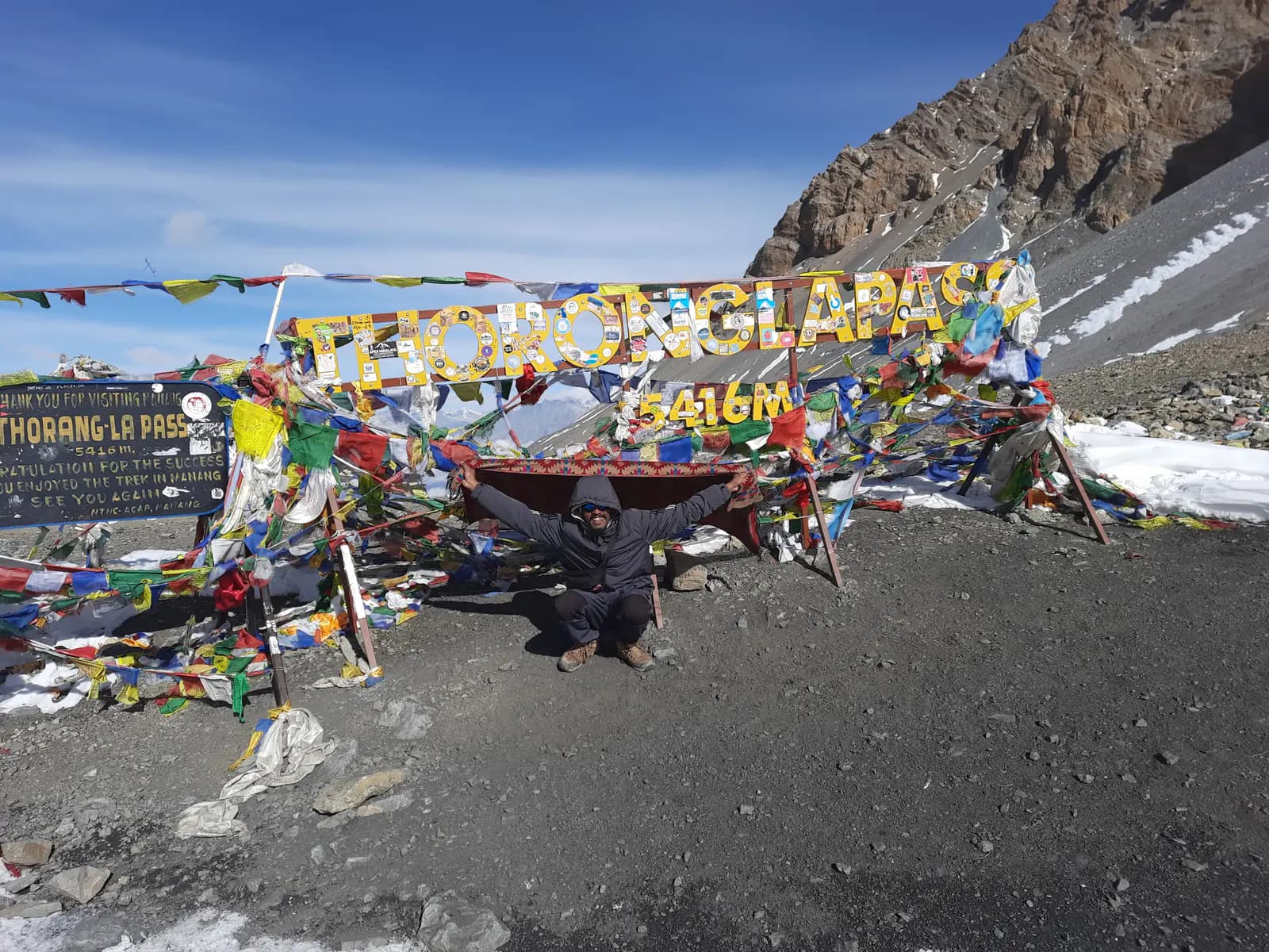
The cairn, the prayer flags, and the hand-painted sign reading 5,416 m. On a clear morning you can see the Annapurnas behind you and the brown Mustang desert opening ahead, two completely different countries either side of one ridge. Do not linger.Fifteen or twenty minutes for photographs and a hot drink from a flask, then down. Standing about at 5,416 m in wind chill is how people get cold injuries and how mild altitude symptoms become serious ones.
09:00–14:00, the descent to Muktinath
This is the part nobody warns you about. From the pass it is 1,656 m of continuous descent over about 10 km, first on loose scree, then on a long, dusty, knee-punishing zigzag down to Charabu and finally Muktinath. It takes four to five hours and it is where most of the twisted ankles and blown knees happen, because people relax after the summit photo and stop concentrating. Trekking poles are not optional on this descent.
Arrival at Muktinath (3,760 m)
Warm rooms, hot showers, and, for many trekkers, the best night's sleep of the trip, 1,650 m lower than the night before. Muktinath itself is a significant pilgrimage site for Hindus and Buddhists, and worth an hour in the morning before you continue down the Kali Gandaki.
| 03:30 | Wake, breakfast, final kit check at High Camp |
| 04:00 | Depart by head torch, −10 to −20 °C |
| 06:30 | First light; usually the coldest hour of the day |
| 08:00–09:00 | Thorong La, 5,416 m: 15–20 minutes maximum |
| 11:00 | Charabu; the gradient eases, the air thickens |
| 13:00–14:00 | Muktinath, 3,760 m |
Why Thorong La is genuinely dangerous
Most operators describe the pass as "challenging but rewarding" and move on. We would rather set out the four hazards properly, because a trekker who understands them is a trekker who turns back at the right moment.
1. Altitude: 5,416 m is very high
At the pass, barometric pressure is roughly half that at sea level, so each breath delivers about half the oxygen. The risk of acute mountain sickness rises sharply with altitude and with speed of ascent, and the two serious forms, high-altitude pulmonary oedema (HAPE) and high-altitude cerebral oedema (HACE), become real possibilities above 4,500 m in poorly acclimatised people. The Wilderness Medical Society clinical practice guidelines for acute altitude illness are the standard reference here, and their central recommendation above 3,000 m is unglamorous: raise your sleeping altitude by no more than about 500 m a day, with a rest day roughly every 1,000 m. The circuit's Manang rest day exists precisely to satisfy that rule. Full detail in our Annapurna Circuit altitude sickness guide.
2. Weather: it changes faster than you can walk
Thorong La is a gap between two very different climates and it behaves like one. Even in a settled autumn week, cloud can build from mid-morning and wind can go from a nuisance to genuinely dangerous within an hour. In a whiteout the trail across the broad upper section is not obvious, and there is no shelter between High Camp and Charabu. The pass does not need a full storm to become serious; it needs a couple of hours of driving snow and poor visibility.
3. Cold and wind chill
Dawn temperatures at the pass in October and November typically sit between −10 °C and −20 °C, and a 40 km/h wind takes the effective temperature far lower. Frostbite on this pass is almost always fingers, toes, nose and ears, and almost always follows the same pattern: thin gloves, a stop for photographs, wet socks from the previous day, or a hand out of a mitt to work a camera. The cold-weather kit list for this specific day is on the Annapurna Circuit packing list.
4. The descent trap
The summit is only a third of the day. People celebrate at the cairn, then face five hours of steep loose descent with tired legs, low blood sugar and dwindling concentration. Ankle and knee injuries on the Muktinath side are more common than altitude evacuations. Eat at the pass, use poles, and treat the descent as the second half of the day rather than the way home.
Our Thorong La safety protocol
What we actually do, rather than what we say in a brochure. This is the same protocol on every departure, whatever the group has paid.
- A non-negotiable acclimatisation day at Manang (3,540 m). Every itinerary we sell includes it, with a climb-high walk to Ice Lake, the Gangapurna viewpoint or Praken Gompa depending on how the group is going. We will not sell a circuit that skips it.
- Daily pulse oximetry above 3,000 m. Your guide records oxygen saturation and resting pulse each morning and evening. A single low reading means little; a downward trend across two days means we change the plan.
- A weather decision the evening before. Your guide checks the forecast at Manang and again at Yak Kharka and Phedi, and talks to the lodge keepers and the guides coming the other way, who know more than any app about what the pass did yesterday.
- An agreed turn-around time.If the group is not at the pass by roughly 10:00, we turn back to High Camp. This is stated to everyone the night before, so it is never a negotiation at 5,200 m.
- The group stays together. No one walks the pass section alone, ahead or behind. Where a group splits by pace we run two guides, and a porter or assistant guide stays with the slowest walker.
- Supplementary oxygen and a first-aid kit on the pass section. Carried from Manang onwards, alongside a pulse oximeter. Oxygen buys time to descend; it is not a reason to keep climbing.
- Descent is always the answer. If a trekker has symptoms of HACE or HAPE, we go down immediately, at night if necessary, and we do not wait for a helicopter to decide for us.
- An evacuation plan before you leave Manang. Your insurance details and emergency contacts are with the guide and in our Pokhara office, and helicopter evacuation from the Manang and Muktinath sides is arranged through our office 24 hours a day.
Our guides are Nepal government-licensed. Rohit Timilsina, our co-founder, holds licence #1497, and the wider team includes Bishal Baral (#1751), Karuna Acharya (#5213) and Hem Dhoj Waiba (#13854). You will be told your guide's name and licence number before you fly.
The acclimatisation you need before Thorong La
Almost every serious altitude problem on the circuit can be traced back to what happened in the four days before the pass, not on the pass itself. This is the ascent ladder we use, and why it is shaped this way.
| Night | Sleep at | Gain | What it is doing for you |
|---|---|---|---|
| Chame | 2,670 m | +810 m | Below the threshold where the 500 m rule really bites |
| Upper Pisang | 3,300 m | +630 m | First night that feels high; the high route helps |
| Manang | 3,540 m | +240 m | Deliberately small gain before the rest day |
| Manang rest day | 3,540 m | 0 m | Climb high to 4,000–4,600 m, sleep low. The single most valuable day of the trek |
| Yak Kharka | 4,050 m | +510 m | At the limit of the guideline, deliberately |
| Thorong High Camp | 4,800 m | +750 m | Above the guideline, the one aggressive night, and why the rest day matters |
| Thorong La (crossed) | 5,416 m | +616 m | Touched, not slept at. Down to 3,760 m the same day |
Two honest notes on that table. First, the Yak Kharka to High Camp gain of 750 m exceeds the usual 500 m guideline, and there is no way around it. There is nothing to sleep in between. That is why the Manang rest day is compulsory and why the alternative of sleeping at Phedi (4,450 m) and doing a longer pass day is a legitimate choice for slower groups. Second, the Himalayan Rescue Association aid post at Manangruns a free altitude talk most afternoons in season; we send every group to it. Ninety minutes of a doctor explaining what a headache at 4,000 m means is worth more than anything on this page.
The full ascent profile, with the elevation graph, is on the Annapurna Circuit map and altitude profile. The lakes route builds far more altitude in before the pass. See the 11-day lakes route.
When NOT to cross Thorong La
There is no shame in this list and we would rather you read it now than argue about it at High Camp.
- If anyone in the party has symptoms of altitude illness.A headache that will not clear with fluids and paracetamol, vomiting, breathlessness at rest, a wet cough, unsteadiness on the feet: any of these means down, not over. There is no scenario in which crossing a 5,416 m pass improves altitude sickness.
- If the forecast is bad or the pass turned people back yesterday. Waiting a day at Phedi costs one day. It is the cheapest insurance on the trek.
- In fresh deep snow, without local advice. After heavy snowfall the trail can be waist-deep and unmarked. Local lodge keepers know when it has been broken; we ask them.
- In mid-winter, on a first Himalayan trek. December to February the pass is often impassable, and the High Camp lodges may be closed. It is crossable by experienced, properly equipped parties in a settled spell. It is not a first-timer's proposition.
- If you are not at the pass by the turn-around time. Late on the pass means late on the descent, in wind, possibly in the dark, with a tired group.
- If your gut says no. Guides listen to this more than trekkers expect. If you want to stop, say so.
The alternative if you cannot cross is not the end of your trip. From Manang or Phedi you retrace to Chame and take a jeep out, which is an ordinary and unremarkable thing to do. From Muktinath side, you have already finished the hard part. Helicopter evacuation exists for medical emergencies, not for schedules.
Thorong La through the seasons
| Season | Pass conditions | Dawn temperature | Verdict |
|---|---|---|---|
| Spring (mid-Mar to mid-May) | Usually open; residual snow early in the season, softening later | −10 to −15 °C | Excellent, warmer than autumn, hazier views |
| Monsoon (Jun to mid-Sep) | Crossable in dry spells but cloud, wind and landslides on the approach | −2 to −8 °C | We do not run it |
| Autumn (late Sep to Nov) | The most reliable window of the year | −10 to −20 °C | Best. Book early: it is busy |
| Winter (Dec to Feb) | Frequently impassable after snowfall; High Camp lodges may close | −20 to −30 °C | Experienced parties only |
Note that nobody officially "closes" Thorong La. There is no barrier and no permit that gets withdrawn. It simply becomes impassable, and whether it is passable on a given morning is a judgement made by the guides and lodge keepers at Phedi. Month-by-month weather is on our best time to trek the Annapurna Circuit page.
Fitness and pace for the crossing day
Fitness will not protect you from altitude illness (that is a separate physiological lottery), but it changes everything else about the day. A fit trekker walks the pass at a comfortable, sustainable, slow pace, arrives with reserves, and descends safely. An unfit trekker arrives at the cairn empty and then has to do the hardest five hours of the trek.
The honest benchmark: if you can walk seven hours in the British hills with a 5 kg pack, two days running, and feel fine on the third morning, you have the base you need. Add hill repeats and long descents to your training: the Muktinath side punishes quadriceps far more than the climb punishes lungs. Our difficulty and fitness guide has the eight-week plan.
On the day itself, the rule is slower than feels natural. Your guide will set a pace that seems absurd for the first hour. Match it. Trekkers who go out fast from High Camp are the ones sitting down at 5,100 m.
Insurance for Thorong La: the 5,416 m problem
This is where UK trekkers get caught. Most standard and annual multi-trip travel policies cap trekking cover somewhere between 2,000 m and 4,000 m, which means they would not respond to an incident on Thorong La at all. You need a policy that names an altitude limit at or above 6,000 m and states helicopter search and rescue explicitly.
| Provider | Cover type | What to check in the wording |
|---|---|---|
| BMC (British Mountaineering Council) | Trek and Alpine policies used widely by UK hillwalkers | The altitude band you select covers 6,000 m |
| True Traveller | Adventure pack add-on | Trekking altitude limit and helicopter rescue both named |
| Snowcard | Specialist mountain activity cover | Activity band matches "trekking to 6,000 m" |
| World Nomads (UK) | Plan-dependent adventure cover | Altitude limit on your specific plan, not the marketing page |
A helicopter rescue from the Manang or Mustang side runs to several thousand pounds and is billed to you or your insurer, not to us. Buy the policy before you fly from the UK: no insurer will cover an incident already under way. Permit and paperwork requirements are on the permits page.
Thorong La deaths: the honest record
We publish this because a safety page that omits it is not a safety page.
On 14 October 2014, at the height of the autumn trekking season, the remnants of Cyclone Hudhud crossed northern India and struck the Nepal Himalaya as an unseasonal blizzard. Snow fell for around thirty-six hours. Trekkers and Nepali staff were caught in whiteout conditions on and around Thorong La, some in the open, some in lodges cut off by avalanche and snow. At least 43 people died across the Annapurna region, trekkers from several countries alongside Nepali guides, porters and villagers, making it the deadliest incident in the history of Nepali trekking. It was widely reported at the time by the BBC, the Guardian and Nepali outlets, and prompted a government review.
Several things changed afterwards, and they matter to anyone crossing today: weather-warning dissemination to lodges and check posts improved, check-post registration at Manang and Muktinath became more rigorous, and the informal practice of guides sharing pass conditions in the evening became near-universal. The 2014 storm was exceptional. It was also survivable for many of the parties that turned back, and fatal for many that pressed on.
Outside that event, deaths on Thorong La are rare in relation to the numbers crossing, and the recurring causes are consistent: altitude illness in trekkers who ascended too fast, hypothermia and exposure in bad weather, and cardiac events. There is no official public register of trekking fatalities in Nepal broken down by pass, so we do not quote an annual figure. We would only be making one up. What we can say is that the identified causes are the ones this page has spent two thousand words on, and all three are reduced by acclimatising properly, checking the weather, and being willing to turn round.
How we source and check the safety claims on this site is set out in our editorial policy.
Safety question about the pass? Message us directly: 07344 063016